

ASH undertook a landscape and visual assessment of the Pirnhall Interchange development
ASH was commissioned to undertake an assessment of the Pirnhall Interchange commercial development based on the existing proposals and to comment and develop the proposals to planning stage.
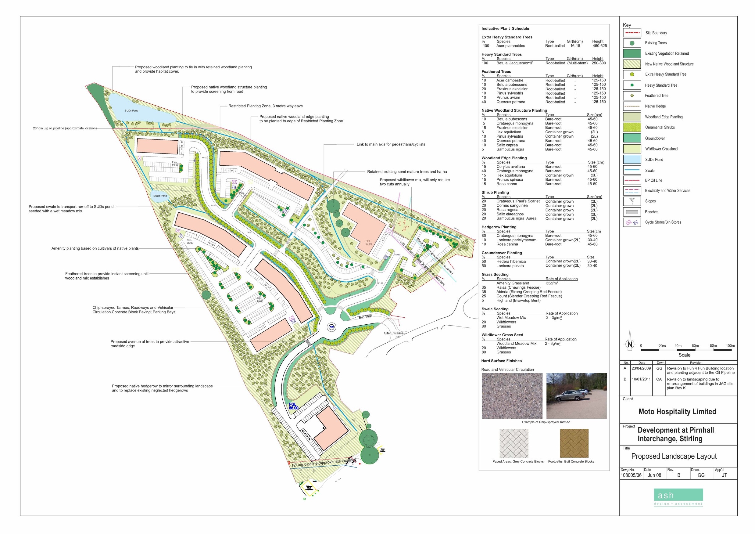
The proposed development site is located to the north of the Moto Service Station between the M9 and M80 motorways, just off the Pirnhall roundabout to the south of Stirling. The surrounding area mainly consists of undulating mixed farmland in a more elevated location than the proposed site. To the north east is the Pirnhall area of Stirling which is screened from the development site by foreground trees.
The proposals are situated on a relatively steep site with the south west section being the highest point, and the site slopes away to the north east until level with the M9.
Vegetation consists of mainly rough grassland with the remnants of past field boundaries in the form of stone walls and neglected hedgerows. The neglected hedgerows form the main vegetative structure, with a number of mature trees found along old field boundaries.
In the north of the site there is a small plantation that provides screening to the adjacent M80 motorway. The southern boundary consists of coniferous trees which provide screening to the Moto service station.

Key Tasks
Landscape and visual impact assessment
Landscape design
Masterplanning
Visualisations
Stakeholder consultation
What we did
The landscape masterplan was designed to tie in with existing site context, and minimise potential landscape and visual impact whilst enhancing the appearance of the proposals from key viewpoints.
An assessment of the visual impact of the scheme from key viewpoints was prepared with reference to:
- discussion with the client and architects on the likely nature of the proposals
- a desk based assessment identifying likely visual receptors using photographs and Ordnance Survey 1:25,000 Mapping
- field assessment based on the view gained looking from the proposed development location to the receptors to assess the likely impact of the proposals
The key viewpoints included the Wallace Monument, Stirling Castle and Top of the Town Cemetery; Bannockburn Memorial and Heritage Centre; and users of the M80, M9 and Pirnhall Roundabout.
Having undertaken the visual assessment and site survey, the existing scheme was reviewed with an initial review on how the development could be mitigated through design and incorporated into the existing site context.
It was agreed that to enable the building to sit more comfortably within the existing site topography that the building layouts should be re-orientated and given a more curvilinear plan-form following the existing contours of the site to achieve a more compatible ‘fit’ with the landscape and achieving a more satisfactory elevation to the motorway and other nearby visual receptors. In doing so the buildings also effectively screen the large surfaces of the car parking areas reducing the scale of the development on views from the identified visual receptors.
It was intended to retain as much of the existing vegetation as possible and this will include a number of the mature ash and birch trees found on old field boundaries. This will integrate the proposals within the existing context whilst minimising the initial impact from a new development. The retained woodland vegetation was to be further strengthened by a new native woodland mix which will help break up and soften the more rigid lines of the development. This will create a succession of woodland further enhancing the existing site and providing suitable screening from the adjacent M80 and M9 as well as the nearby settlements.
Pedestrians and cyclists would be able to access the site from the proposed bridge which will be linked to the site by an arrival space which will include a seating area. This central arrival space will become a hub for all bridge users and be linked to the main thoroughfare by a tree lined path.
A requirement for the proposed development was the provision of Sustainable Urban Drainage System. This was achieved by a number of swales running adjacent to internal roads and buildings. It was intended that the surfaces for the footpaths and paved areas will consist of permeable paving blocks in natural shades and provide further sustainable drainage in allowing water to drain away naturally.
Planning consent was granted in 2009 and the site was purchased by Moto Hospitality Ltd. subsequently, but currently still remains undeveloped.
Find out more
We’re always happy to answer your questions. If you’d like to find out more about the services we can offer for your project, you can email us on info@ashglasgow.com or call 0141 227 3388.